


TOP > Service&Product > Sediment and Weather Condition Notification System
System that Supports Disaster Prevention Activities by Extracting and Analyzing Observation and Weather Data to Provide Real-time Information, and Resident Reports Shared by Users
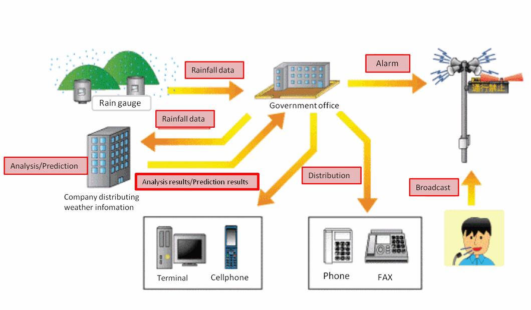
The Sediment and Weather Condition Notification System extracts the required data (rainfall and water level) from observation systems operated by local governments, analyzes them with weather information. Furthermore, it provides the analitical reports to residents in the form of real-time Sediment Control and Weather Information through websites. It enables communication between the system operator and the residents by phone, facsimile, etc.
The system supports the autonomous disaster prevention activities of residents by providing information in normal periods. Further, local governments use the system to support disaster prevention activities in timely-manner and appropriate ways. It thus helps local governments and residents prepare for disasters.
Features
Our system realizes features as below;- Provides, through the website, real-time reports on weather information both from local governments and the Meteorological Agency.
- Shares the collected weather information via phone or facsimile.
- Report reception function to receive information on signs of imminent landslides, etc., from residents by phone or facsimile.
System Configuration
Case Study
01
Sediment and Weather Condition Notification System
This system receives rainfall information from debris flow telemeters, combines it with weather information, and provides residents with voice, character, and image information as Sediment and Weather Condition Information by phone and facsimile and through the Internet. It also enables residents to send information to municipal governments.
02
GPS Landslide Automatic Observation SystemOsaka Prefectural Government
Conventionally, the land manager determines the degree of danger on the
basis of the observation of the expansion/contraction and inclination of
a slope, as well as on the basis of the weather information. This system
based on the GPS technology enables highly accurate observation and the
transmission of the observation data to the management office through a
network in order to analyze the sediment information. The professional
report on stability check is available through the website.(*)
* This service is conditional on a separate maintenance service contract.